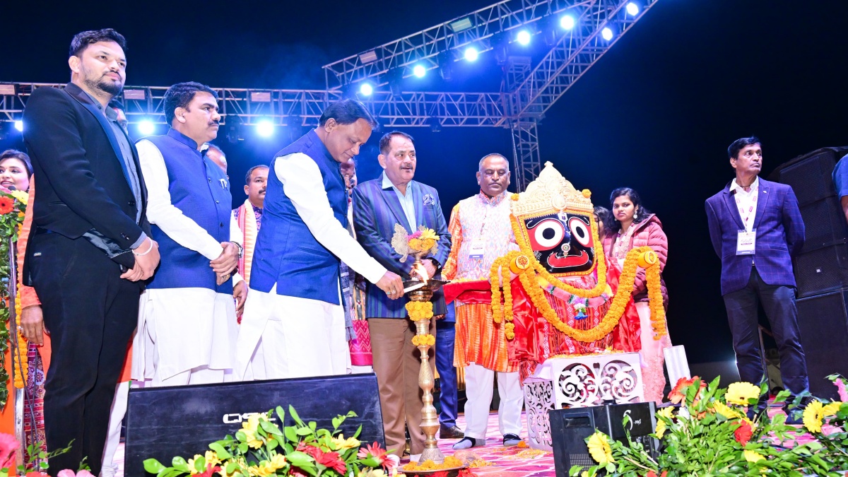
Kashmir tribes report by Kashmir correspondent
ضلع اننت ناگ ANANTNAG
ضلع اننت ناگ Anantnag District is in southern sector of Jehlum Valley. It is because of its rejuvenating climate, the inspiring majesty, its lofty mountains, the melodious flow of sweet waters of its springs and streams, fertile soil, fragrant flowers and delicious fruits that the district has come to be synonymous with greatness.
Geographically the district lies between 33o-20′ to 34o-15′ north latitude and 74o-30′ to 75o-35′ east longitude. The entire Southern sector of the district, which is contiguous with tehsils of Reasi, Banihal and Kishtwar of Jammu province, and Eastern sector which is contiguous with tehsil Kargil of Ladakh division comprises of thick forests and mountains.
The Northern and Western sides of this district are bounded by Pulwama district while Kulgam district falls in its west. Of all the districts of the state, Anantnag claims the largest number of streams (Nallas) like Sandran, Brengi, Arpath and Lidder. The most important among these is Lidder which takes of from Sheshnag lake and irrigate maximum area of the district.The area of the district after carving out district Kulgam in year 2007 stood at 3574 Sq. Kms, which constitutes about 1.31% of the total area of Jammu & Kashmir state. As per Census 2011, the population of the district is 10.70 lac with 5.52 lac Males and 5.17 lac Females. As per the report of Revenue authorities, the district consists of 395 Villages having 01 Municipal Council and 09 Municipal Committees.
There are twelve Tehsils Viz. Anantnag, Bijbehara, Dooru, Shangus, Kokernag, Mattan, Sirigufwara, Shahabad Bala-Verinag, Sallar, Qazigund, larnoo and Pahalgam which have further been sub divied into 34 Nayabats (Land Revenue Circles) and 96 Patwar halqas. These villages have also been divided into 16 Community Development Blocks Viz. Achabal, Breng, Dachnipora, Khoveripora, Qazigund, Shahabad, Chittergul, Vessu, Bijbehara, Pahalgam, Shahabad-Hiller, Larnoo, Shangus, Sagam & Verinag . For Law & Order purposes there are 09 Police Stations and 06 Police Posts in the district. Owing to proximity of Peer Panchal Range, which stretches in its South and South-East, the district has a more temperate climate in summer than other districts of the Valley.
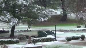
In winter, however, snowfall is heavier and temperature is relatively low. Being engulfed on two sides by mountains, the monsoon does not generally reach the district. The rainfall is often excessive in Spring, moderate in Summer, deficient in Autumn and moderate in Winter. The name of Anantnag District according to a well-known archaeologist, Sir A.Stein from the great spring Ananta Naga issuing at the southern end of the town. This is also corroborated by almost all local historians including Kalhana according to whom the town has taken the name of this great spring of Cesha or Ananta Naga “land of countless springs”. The spring is mentioned in the Neelmat Purana as a sacred place for the Hindus and Koshur Encyclopedia testifies it. The district as well as its headquarter town are also called Islamabad.
Regarding this second name no mention is to be found in the old chronicles of Kashmir. It is however, said that the name of Islamabad was assigned to the town by one Islam Khan who was the Governor of Kashmir during the Mughal rule in 1663 A.D., but the change in its nomenclature proved temporary and during the reign of Gulab Singh the town as well as district again resumed their old name, Anantnag, but stillbut still the name Islamabad is Popular among common masses, though officially the name Anantnag is used. Before the advent of Muslim rule in 1320 A.D., Kashmir was divided into three divisions, viz; Maraz in the south, Yamraj in the centre and Kamraj in the north of the Valley. Old chronicles reveal that the division was the culmination of the rift Marhan and Kaman, the two brothers, over the crown of their father. The part of the valley which lies between Pir Panjal and Srinagar now called the Anantnag was given to Marhan and named after him as Maraj. While Srinagar is no longer known as Yamraj, the area to its north and south are still called Kamraz and Maraz respectively. Lawrence in his book “The Valley of Kashmir” states that these divisions were later on divided into thirty-four sub-divisions which after 1871 were again reduced to five Zilas or districts.
TOURIST PLACES:
Verinag .
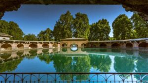
Verinag on the road to Jammu is another spring of great importance and beauty with deep blue water which also issues from the bottom of high scarp of a mountain spur and here again Jehangir built a pleasure garden and a summer house. An octagonal pavement has been raised around the spring by the Emperor Jehangir. The emperor was infatuated with the beauty of Verignag to the extent that while breathing his last at Chengas village near Rajouri he wished to be buried at Verinag. And after the completion of the construction design of the spring and the nearby garden he has written that the traveler who has travelled through the earth can hardly give any example of another place of such a beauty. This tourist resort is in Tehsil Shahabad Bala and is about 26 Kms away from Anantnag Town. A tourist bungalow, a rest house and some huts have been constructed at this place.
Achabal :
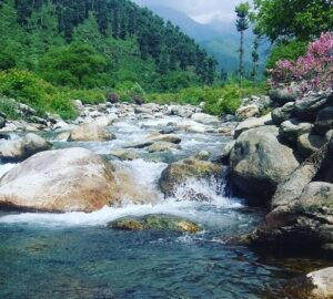
Perhaps the most beautiful of all the springs is Achabal which gushes out of the Sonsanwar Hill and was at once enlisted by the Emperor Jehangir in the service of beauty and pleasure. It is said that the Brengi Nallah which disappears at Dewalgam in the fissures of limestone is the real source of the Achabal Spring. The water of this spring which flows through this garden in three channels, is beautifying and ornamenting this terraced garden beyond imagination. The fountains that have been laid through the water channels add to the charm of this Mughal garden. The health resort of Achabal lies in the south east of the District at a distance of 09 Kms from the district headquarter.
Kokernag:
This health resort lies in the South East of the District at a distance of 25 Kms. A famous spring called “Kokernag” gushes out from the foot of the nearby hill covered with evergreen pine trees. A terraced garden and a Botanical garden with delicately maintained flower beds of different varieties and hues covered and protected with beautifully pruned evergreen shrubs and the existence of lofty and majestic chinars is an enchanting sight to be imbibed. The music of the health giving, refreshing and appetizing running waters of the stream have left little chances of not to be enchanted and mesmerized by this heavenly touch. This beautiful garden has been developed during the rule of Bakhshi Ghulam Mohammad. Keeping this attraction and irresistible appeal of this tourist spot in view, Tourism infrastructure is also being developed through Tourist Development Corporation by way of construction of rest houses, tourist huts and expansion of other facilities. While enjoying the rejuvenating and invigorating feast of this destination one cannot miss to notice the Asia’s biggest trout rearing farm situated on the western side of this garden.
Pahalgam
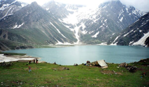
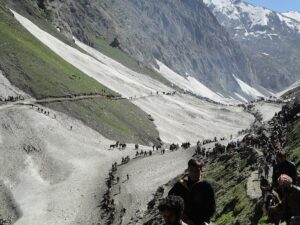
Pahalgam is one of the famous health resorts of Jammu and Kashmir State. It is situated in the north east of District Anantnag among lofty hills covered with evergreen forests. Its cool invigorating and pleasant climate, the melodious flow of Lidder Nallah attract tourists not only from within the country but also from abroad as well. It is also an important transit camp on the way to holy Amar Nath Ji Cave, which is 72 Kms away from the District Head-Quarter.
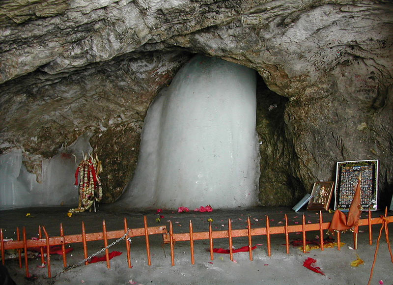
Shri Amarnath ji
“For those who journey with faith, it is a rewarding experience, this simple visitation to a cave-shrine, the home of the Himalayan mendicant who is both destroyer and healer, the greatest of the Hindu God”
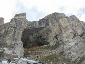
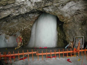
Anantnag District is famous for the Amarnathji cave situated at Mount Amarnath whose altitude is about 5,486m above sea level. The world famous shrine of Amarnathji is situated about 48 Kms. from Pahalgam and attracts devotees from all over India. It is located in the upper reaches of District Anantnag at an altitude of about 13,000 ft. from the sea level. Because of this height, the cave is covered with snow for most of the year. Only for a short period in summer, the entrance is accessible. The cave is an ice cave, it contains a certain amount of ice stalagmites.
The cave is a holy place for Hindu pilgrims, because of its ice content. The ice pillar present inside the cave is also called ice lingham, the phallic symbol of Lord Shiva. Two smaller ice stalagmite represent Parvati, his wife, and Ganesha, his son. The Hindu pilgrims also believe, that the height of the lingham increases and decreases with the phases of the moon. In the month of Shravan, on the full moon in August, thousands of Hindus go on a pilgrimage up to the cave. At this time the lingam reaches its biggest size.
The majority community in the district always welcomes the devotees with wide open arms, while the yatries are on their way to and from the cave. Enroute one come across scenic beauty of Chandanwari, Sheshnag and Panjtarni. The temples of Mattan, Martand, Anantnag and Bijbehara which fall enroute are also worth seeing.